


étape 10 le bleymard /pont de monvert

PatriceCocuaud
User
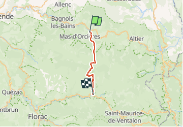

Length
19.9 km

Max alt
1699 m

Uphill gradient
656 m
Km-Effort
29 km

Min alt
900 m

Downhill gradient
828 m
Boucle
No
Creation date :
2022-09-01 07:08:19.356
Updated on :
2022-09-01 13:59:11.114
5h57
Difficulty : Medium

FREE GPS app for hiking
 SityTrail
IGN / Geographical institutes
SityTrail Plus
The world is yours!
About
Trail Walking of 19.9 km to be discovered at Occitania, Lozère, Mont Lozère et Goulet. This trail is proposed by PatriceCocuaud.
Positioning
Country:
France
Region :
Occitania
Department/Province :
Lozère
Municipality :
Mont Lozère et Goulet
Location:
Unknown
Start:(Dec)
Start:(UTM)
558461 ; 4926163 (31T) N.
Comments